El Niño is one of the most interesting weather spectacles that occur on planet Earth. While it is a source of a great deal of fascination in the scientific community, its effects can be devastating.
Despite the fact that people have observed El Niño and La Niña since the 1600s, very little is known about what causes these unusual weather patterns.
We have come to fear the unusual weather patterns that come when an El Niño year is forecasted, but many people don’t know why.
Let’s take a look at what is known about this climate cycle and some of the issues that it can cause throughout the world.
What is El Niño?
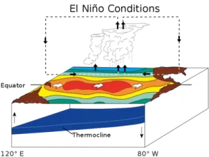
El Niño is the weather pattern that occurs when the water warms to a higher than average temperature in the eastern tropical Pacific ocean. This decreases the air pressure above the water, changing weather patterns.
The cascading effect of this warm water can be local if there is only a small rise in temperature (4-5 degrees) or global if the water warms 15 degrees or more.
El Niño and La Niña combined make the weather pattern called the El Niño Southern Oscillation (ENSO) which describes the changing winds and weather patterns that occur with these two extremes.
What is La Niña?
La Niña is the description for the weather patterns as the central Pacific ocean cools back down. This causes air pressure to begin to normalize and reverse the effects of El Niño.
As the La Niña events occur, global weather patterns shift bringing severe weather to different areas of the globe.
Difference Between El Niño and La Niña
There are several key differences between El Niño and La Niña.
- El Niño is begun by a warming trend on the sea surface. The warm ocean water causes a change in air pressure which decreases and shifts the prevailing trade winds. The jet stream dips southward.
- La Niña is caused by a cooling trend on the sea surface. The cooling water causes a shift in air pressure that increases wind shear, shifting the jet stream northward.
- El Niño warming is often followed by a distinct pattern of cooling called La Niña, but not always.
- Sometimes El Niño fades away on its own due to slow ocean water cooling.
- La Niña cooling can be distinct and destructive. It causes tornado activity in the South and Midwest while keeping the West unusually dry.
These weather patterns are so difficult to predict. They’re usually quantified in a percentage of probability which changes as the seasons progress through the year.
How Often Does El Niño Occur?
This oceanic warming and the weather patterns it causes historically occur about every 3 to 5 years.
The entire cycle typically takes about a full year, but it has been known to take several years to equalize.
According to climate.gov, this weather pattern is natural and normal. Because we feel the effects from year to year we tend to think it’s unusual, but it isn’t.
However, the intensity of the El Niño southern oscillation can vary widely from cycle to cycle.
What are the Disadvantages of El Niño and La Niña?
The disadvantages of El Niño are many because of the cascading effects on global weather patterns. Keep in mind that these effects are incredibly hard to predict.
- The weaker winds produced by El Niño events cause the jet stream to move into a more southerly position, changing precipitation levels.
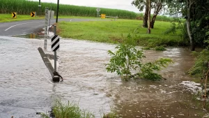
- In the south, El Niño years are marked by heavier than normal rainfall through the fall and spring. It can cause widespread flooding.
- In the north, El Niño years tend to cause fall through spring weather patterns that are more warm and dry than usual.
This can be a blessing to areas like southern California that often suffer from drought conditions. An El Niño year can bring much-needed precipitation to these areas.
La Niña produces a reversing weather pattern as the eastern tropical Pacific ocean cools and returns to its neutral state.
- La Niña events cause the jet stream to shift slightly northward bringing very wet, cold weather to the Pacific Northwest, Canada, and northern states.
- The upper Midwest tends to be a bit wetter than usual while southern areas stay relatively dry and warm.
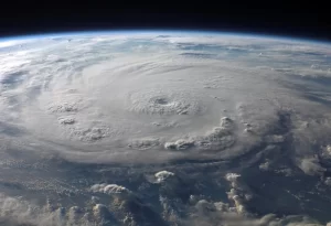
- La Nina tends to increase the number and intensity of Atlantic hurricanes that hit the southeastern US and Gulf of Mexico.
The key to remember is that these weather events are normal. El Nino and La Nina tend to amplify the weather patterns but it’s very difficult to predict how much, when, or where.
It’s also very hard to point to a specific storm and blame it on ENSO. Global weather patterns are caused by intricately overlapping climate conditions.
No single weather anomaly is to blame.
What Happens During El Niño?
El Niño is best described as a climate cycle in the equatorial Pacific Ocean. It has a huge impact on weather patterns around the world.
This climate cycle starts when warm waters that find their origins in the equatorial Pacific Ocean start moving toward the South American coast.
While these waters will occasionally pool and dissipate near Indonesia, an El Niño occurs when the warmest of the surface water begins to upwell offshore in north-western South America.
This cycle will usually last somewhere between nine and twelve months. However, there have been rare occasions where the phenomenon occurs over a number of years, causing weather upheaval.
Is El Niño Wet or Dry?

That depends on where you live. El Niño events shift the normal weather patterns so that places that are normally very rainy are drier and places that are normally warm and dry may get wet weather or even snow.
Forecasters look at both the ocean temperatures and the rainfall generated by storms that move east before declaring an El Niño.
The changing air pressure from El Niño will cause trade winds to weaken and even reverse, so tropical storms tend to shift eastward during the ENSO cycle.
The same type of effect occurs with La Niña events, but as the ocean temperature cools the trade winds revert to their normal directions and weather patterns tend to shift as well.
Though how much precipitation you get with La Niña depends on exactly where the jet stream sits and how much evaporated moisture it is carrying.
What is the Main Cause of El Niño?
Despite the fact that we have known about El Niño since the 1600s, when its effects were first spotted by Peruvian fishermen, we still don’t fully understand what actually causes it.
It is believed that the phenomenon occurs as a result of extensive interactions between the ocean and the surrounding atmosphere.
This means that there are likely a lot of little things that add up to the creation of an El Niño, rather than one specific cause.
The issue is complicated further by the fact that not all occurrences of El Niño are the same, making it remarkably difficult to predict. Sometimes it is correctly predicted but then is a very weak cycle.
The El Niño that occurred between 1982 and 1983 is considered to be one of the largest instances of the cycle, as is the one that happened in 1997.
There were 6 observable ENSO cycles between 2000 and 2020, but they have all been much smaller.
That is unless you live along the Pacific Coast. If you do, you noticed intense wave activity and record beach erosion during the 2015-16 ENSO.
Furthermore, the ocean and surrounding atmosphere also have varying patterns between El Niño occurrences. This makes it even more difficult to predict when they will happen and what their effects will be.
Thankfully, there is still some predictability, as scientists can monitor the ocean temperatures in the upper 656 feet of the water.
They look for indicative temperature shifts through the equatorial Pacific region.
However, this is not a foolproof method and doesn’t provide the actual explanation for why El Niño happens.
In some cases, these temperature shifts occur but are not followed by the storms and trade wind shifts that characterize a strong El Niño.
When Does El Niño Happen?
While a strong El Niño cycle can last for a year or more, the cycles are fairly irregular in occurrence.
The general pattern suggests every three to five years, but gaps between El Niño cycles have been as short as two years or as long as seven.
When they do occur, they will usually form at some point during the spring. This leads to them attaining peak strength right around the winter months of December and January.
This tendency to bring noticeably different weather around Christmas time is what led to the cycle being given the El Niño name in the 1600s.
Back then it was referred to as El Niño de Navidad, which literally translates to ‘The Christ Child’.
The cycle will take at least another four to five months for the conditions to revert back to pre-El Niño states. This equalizing part of the cycle is called La Niña.
These conditions can take much longer to equalize, though. Some ENSO cycles have been measurable for 2 years.
What is known is that El Niño has been happening since the beginning of the world. Evidence of the cycle can be seen in deep sea muds and ice cores in the ocean.
Is There Always La Niña With El Niño?
Surprisingly, no. El Niño is known to occur and simply fade away rather than have a distinct cooling reversal.
La Niña is known for high trade winds that push water into the western Pacific, and this does not always accompany the end of an El Niño pattern.
This is another mystery surrounding the weather pattern.
What Are the Negative Effects of El Niño?
Scientists try to keep track of and predict the El Niño cycle because it can have negative effects on weather conditions like the storms we already discussed.
- The El Niño that occurred between 1982 and 1983 is believed to have caused somewhere around $10 billion in weather-related damage throughout the world.
- El Niño makes it harder for hurricanes to form over the Atlantic Ocean, due to the creation of stronger wind shears and the formation of stable air.
- This shift makes eastern Pacific hurricanes a major problem. They batter parts of Peru, the southern United States and the surrounding regions.
- El Niño also leads to higher amounts of rainfall across the southern United States and in Peru causing flooding.
- Conversely, rainfall tends to lower in the Pacific Northwest and in Ohio and Tennessee during a cycle, which is tough for timber stands and farming communities.
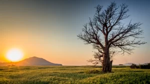
- El Niño leads to widespread droughts in other areas. Africa, India, Southeast Asia, Australia, and the Pacific Islands have all been known to experience severe water shortages during an El Niño.
These negative effects impact livelihoods, destroy homes, create famine, diseases borne by flooding, and even warfare as countries struggle to get food supplies during drastic floods or droughts.
What are the Advantages of El Niño?
Interestingly, the shift that causes disaster in many parts of the world can bring benefits to others.
The International Monetary Fund has studied the economic impact of El Nino around the world. Predictably it is devastating for hard-hit areas while those still producing commodities can cash in.
- Areas previously struggling with drought often receive higher than usual amounts of rainfall during El Niño or La Niña patterns.
- Fishing communities in South America receive a bounty. The upwelling caused by warm water brings phytoplankton and a wide assortment of fish to the coast, swelling the fisheries along Peru, Ecuador, and Chile.
- The economic impact can be good for some commodities as access to ores and things like that is hampered by flooding and bad weather.
- In some areas, diseases like Malaria will see a definite drop in transmission rate because the area dries out a bit killing off mosquitoes.
The main advantage is that areas that don’t normally receive a lot of water will receive a lot all at once.
It can cause a lot of flooding, but it can also help to replenish reservoirs and groundwater sources.
Will There Be an El Niño or La Niña in 2022?
According to the National Oceanic Atmospheric Administration (NOAA) ENSO Blog, 2022 is slated to be an average year with La Niña tendencies increasing through the fall and into the winter.
This will be the third year of cooling in the equatorial Pacific region which should keep the jet stream shifted a little to the north, keeping the American west in a drought.
This is not good news for the 50% of the US that is in some state of drought.
Final Thoughts
Despite the fact that El Niño has been occurring since before the dawn of humanity, we still know so little about this frequent weather pattern.
In particular, scientists are struggling to find specific reasoning behind the occurrences.
Usually, the best we can do is track changes in weather and ocean surface temperature and hope that forecasts that result from this data offer accurate representations of what will happen should El Niño occur.
What happened where you live during the last El Niño? Let us know in the comments below!